In 1995, Bolivia’s North Yungas Road was declared the World’s Most Dangerous Road by the Inter American Bank after a feasibility study was conducted to determine the safety of the road for drivers. It was estimated that around 200 – 300 people died there each year1 in accidents.
The North Yungas Road is about 60km long and is considered the deadliest portion of the Death road. The road starts from La Paz, with an average height of 3,600 meters above sea level, and ascends to La Cumbre at 4650 meters above sea level.
The Yungas road is an 80km long route, which cuts into the side of the Andes mountain, on the eastern range known as the Cordillera Oriental. It links the city of La Paz to Coroico, in the Yungas region of Bolivia.
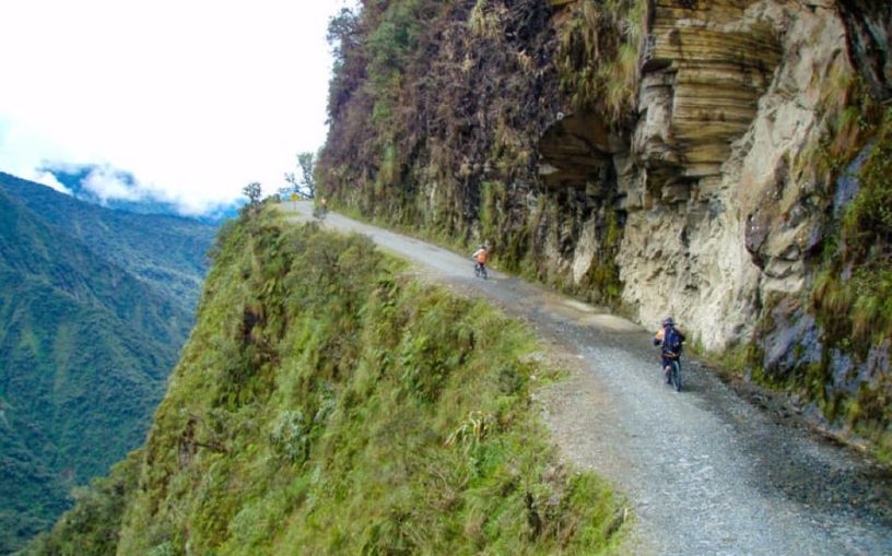
Most of the North Yungas Road is only 3.5 meters wide, barely enough for one car. There are about 34 kilometers of asphalt road, and another 33 of rammed earth and mud, with harsh bends, large stones littered on the path and no guardrails along the cliff’s edge. In some sections, waterfalls fall directly on the road, and others are covered in mist, since it is a rainy area all year round.
On one side of this cramped road is the solid rock of the Andes mountain and on the other, a 600 meter drop into the abyss. The Yungas Road is made even more dangerous by the constant fog caused by warm air from the Amazon, meeting cold air from the mountain.
The fog is usually thick, making it hard to see more than 2 meters ahead. Mudslides coming down the mountain are a risk as well, especially during wetter months.
According to locals, La Cumbre marks the start of the road of death. It is the highest point on the road, about 1700 meters above sea level.
For many years up until 2008, the North Yungas road was considered part of Route 3, in the fundamental road network of Bolivia2. It was the only route connecting La Paz (Bolivia’s administrative capital) with the Amazon Basin, before the construction of the Cotapata-Santa Bárbara section of the road in 2006, which replaced the North Yungas road as an official section of ‘Route 3’.
More than 200 trucks a day had to navigate the road, some carrying goods and livestock, while others carried anywhere from 30 to 100 passengers, until the alternative route was created. The North Yungas road was then closed off to large buses and trucks entirely in 2007. As a result, the deceased along the Yungas road have now fallen to about 30 to 40 a year3.
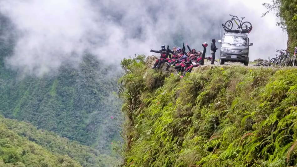
Nowadays, the North Yungas road is only frequented by tourists and cyclists, often accompanied by tour guides.
The route now sees an average of 25,000 cyclists per year, with 29 cyclists dead4 since 1998.
Bolivia ranks 28th out of 31 countries when it comes to safety on roads and highways such as the La Paz highway. The WHO reported in 2018 that Bolivia has a road accident mortality rate of 23.2 deaths per every one hundred thousand individuals.
Bolivia’s most notable road accident occurred on July 24TH 1983, when a lorry driver named Carlos Pizzarroso Inde, veered off the North Yungas Road and into the ravine 300 meters below, killing himself and all 100 passengers in the back of his truck5
Contents
OFFICIAL DEATH TOLLS OF THE
YUNGAS ROAD
The highest number of fatalities from vehicle accidents in a single year was in 1983, with 320 people dead. The number of fatalities on this road before 2006 was between 100 to 200 with some years rising upwards of 300. That meant an average of 26 vehicles per year would fall over the edge into the ravine below6. 2007 to 2010 saw a combined figure of 286 reported deaths and 644 injured on the Yungas road.
In 2011, there were 116 accidents on the Yungas road, leaving 155 injured, and 42 reported dead, according to the Federación Regional de Transporte (Transport Union) of La Paz. In 2016, 274 deaths7 were recorded in La Paz, with most fatalities occurring on the Yungas-Santa Bárbara route. In 2019, the reported numbers were 46 accidents8, 83 deaths9 and 36 injured10. As of 2020, the current death toll stands at 14 dead and 19 injured11.
REGIONS OF THE YUNGAS
LA PAZ: La Paz is the seat of government of the Plurinational State of Bolivia
Distance (from La Paz): 0 km
Elevation: 3,640 m (11,942 ft)
UNDUAVI:
Distance (from La Paz): 42.8 km
Elevation: 2,946 m (9,665 ft)
YANACACHI: 3.5 km from La Paz
Distance (from La Paz): 3.5 km
Elevation: 3,335 m (10,942 ft)
INCA CHACA:
Distance (from La Paz): 4 km
Elevation: 4,503 m (14,774 ft)
LA RINCONADA:
Distance (from La Paz): 211 km
Elevation: 5,100 m (16,700 ft; 3.2 mi)
La Rinconada is a town in the Peruvian Andes. It sits near a gold mine, and is the highest permanent settlement in the world at 5,100 m (16,700 ft.) above sea level,
LA CUMBRE:
Distance (from La Paz): 22.7 km
Elevation: 4.506m (14,783ft)
La Cumbre is a high mountain pass at an elevation of 4.506m (14,783ft) above the sea level, located in the Cochabamba department in the center of Bolivia. It is the highest point of the North Yungas road.
COROICO:
Distance (from La Paz): 103 km
Elevation: 4.506m (14,783ft)
Coroico is a town in the North Yungas Province, in the La Paz Department of western Bolivia.
CORIPATA:
Distance (from La Paz): 113 km
Elevation: 1,587 m (5,206.9ft)
Coripata is a town located in the North Yungas region, in the La Paz department of Western Bolivia
SANTA BÁRBARA:
Distance (from La Paz): 666 km
Elevation: 4,774 m (15,622.8 ft)
Santa Bárbara is a small town in the Sud Chichas Province of the Potosí Department in Bolivia. The town lies at an altitude of 4,774 m at the foot of Cerro Chorolque mountain.
CARANAVI:
Distance (from La Paz): 161 km
Elevation: 976 m (3,202 ft)
This place is situated in Nor Yungas, La Paz, Caranavi is the capital of the Caranavi Province in the Yungas region of Bolivia.
CHULUMANI:
Distance (from La Paz): 116 km
Elevation: 1,700 m (5,600 ft)
Chulumani is a municipality in Bolivia. It is the capital of the South Yungas region of the La Paz Department in Western Bolivia.
PALCA:
Distance (from La Paz): 36.8 km
Elevation: 3,465 m (11,368 ft)
Palca, Bolivia is a location in the La Paz Department in Bolivia.
IRUPANA:
Distance (from La Paz): 143 km
Elevation: 1,800 m (5,900 ft)
Irupana Municipality or Villa de Lanza Municipality is the seat of the Irupana Municipality, the second municipal section of the South Yungas Province in the La Paz Department, Bolivia.
COTAPATA:
Distance (from La Paz): 37.9 km
Elevation: 904 m (2,965.88 ft)
Located in La Asunta, South Yungas province.
ORURO:
Distance (from La Paz): 233 km
Elevation: 3,702 m (12,150 ft)
Oruro is a city in west-central Bolivia. It lies at 12,150 feet (3,702 metres) above sea level in the Altiplano region, 30 miles (48 km) north of Lake Poopó.
It is three hours (by bus) from La Paz.
TARIJA:
Distance (from La Paz): 889 km
Elevation: 1,866 m (6,122 ft)
Tarija is a city in southern Bolivia. It is situated at an elevation of 6,122 feet (1,866 metres) above sea level on the Guadalquivir River.
LA CHOJLLA
Distance (from La Paz): 300 km
Elevation: 2,200m (7,217 ft)#
La Chojlla is a small town in Bolivia, in the South Yungas region
La Asunta
Distance (from La Paz): 198 km
Elevation: 788 m (2,585.30 ft)
La Asunta is a location in the La Paz Department in Bolivia. It is the seat of the La Asunta Municipality, the fifth municipal section of the South Yungas Province.
Sources
- Inter American Bank (1995) www.iadb.org
- Routes and lengths, Administradora Boliviana de Carreteras (2006) www.abc.gob.bo
- Camino de los Yungas, EcuRed. (2019) www.ecured.cu
- El Camino de los Yungas: la carretera más peligrosa del planeta, Atlantida Travel (2018) www.atlantida.opennemas.com
- Bolivia: The big drop, The Telegraph (2002) www.telegraph.co.uk
- Death Road Bolivia, Kanoo Tours (2019) www.kanootours.com
- Viajes hacia la muerte, Los Tiempos (The Times) – 2016
- Agencia boliviana de información (2019)
- Bus crash leaves 14 dead, 21 injured in Bolivia, The Santiago Times (2019) www.santiagotimes.cl
- Correo del Sur (2019) correodelsur.com
- Accidente en la carretera Yungas. Correo del Sur. (2020) www.correodelsur.com
Data gathered from:
The Instituto Nacional de Etadística (National Institute of Statistics, Bolivia. www.ine.gob.bo)
The Administradora Boliviana de Carreteras ( Bolivian Highway Administration, w ww.abc.gob.bo), Los Tiempos (The Bolivian Times) and other reputable news sources